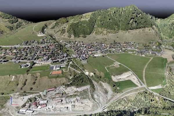
Aerial data acquisition, is the first step in geospatial analysis projects. It will define the road you want to follow. Our own fleet of aircrafts, helicopters and high technology sensors make us able to capture your data anywhere in the world.
We based on the combination of laser scanner, a high-resolution digital aerial camera, very high quality direct georeferencing navigation system (gps-imu) & airborne spectrometer. We have both fixed wing & helicopters.
Our offer includes a wide range of services from the air: the recording of aerial photographs, oblique images, thermal images, laser data, spectral images & airborne electromagnetic spectrometer. From this basic data, we generate numerous products such as digital orthophotos, true orthophotos, surface and terrain models, image-based surface models (bdom), 3d city models, 3d meshes, powerline mapping data and input data for building information modeling (BIM).
Your data acquisition partner all over the world
Orthorectification (Satellite)
The topographical variations in the surface of the earth and the tilt of the satellite or aerial sensor affect the distance with which features on the satellite or aerial image are displayed. The more topographically diverse the landscape, the more distortion inherent in the image. Terrain displacement can be hundreds of meters. Our service includes by draping imagery over a co-registered model of the terrain below, we are able to shift the data closer to its true location on the planet. Any medium and high-resolution imagery, including those with and without an RPC file, can be orthorectified. The accuracy achieved in orthorectification can be further improved upon by the application of ground control points. Once ground control is applied to high-resolution imagery, the data typically achieves an accuracy of 2-meter (m) CE90
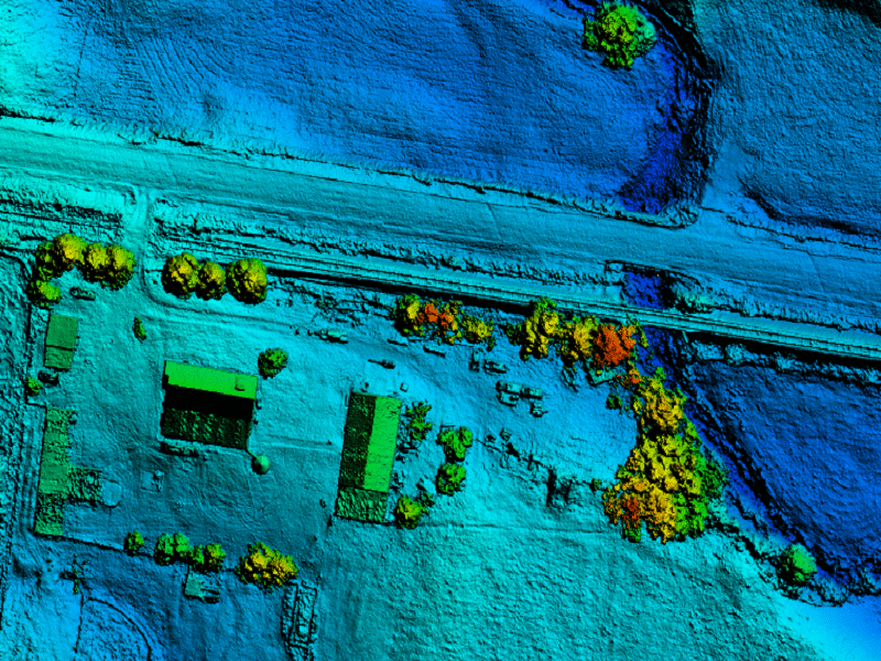
Point cloud Generation
The camera records surfaces and objects using a series of photos taken in a fly-over. By matching different photo perspectives of a single view or object, a point cloud of the object can be generated by surface matching and triangulation. For the Aerial LidarThree-dimensional point cloud is collected simultaneously with the aerial photos, giving each individual point an RGB color value as well as a ground / no-ground classification. Later points to be classified as bare earth, high or low vegetation, building, and so on including RGB mode.
Digital Surface Modelling
Digital representation of terrain based on the height value is known as DEM. Automatic DEM can be extracted from software by using image matching algorithm.
Digital Surface Model (DSM) represents the earth’s surface and including all other objects like buildings, trees and other man made features. DSM is useful in 3D modeling for telecommunications, urban planning and aviation. Infrastructure damage assessment is anlysed by DSM
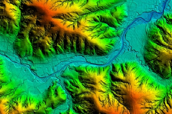
Terrain models
Based on the point cloud obtained during airborne laser scanning, we develop terrain models. Digital Terrain Model (DTM) represents the bare earth ground model only, no other features like buildings, trees and other man made features will be available in this file.Our processed Model can used to analyse through Base mapping, Contour creation, Water flow modeling. Rectification of aerial photography, Line of sight analysis, Surface analysis, 3D visualization rendering Engineering and Infrastructure design.
RTK/PPK/GCP Image Alignment (UAV)
The camera records surfaces and objects using a series of photos taken in a fly-over and put tag GPS in its exif. It is commonly very problematic to update GPS information. Our UAV image referencing services post process all GPS information if using RTK-PPK technology, after Post processing we read and update image EXIF GPS information and rewrite it to our clients for image alignment and optimization.
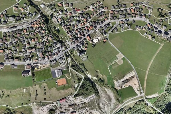
Orthomosaic Generation
Orthomosaic maps offer a photorealistic representation of an area made up from dozens of orthophotos covering all manmade and physical structure. To produce a uniform scale, images are corrected from factors including GPS, camera and environmental conditions. Images are stitched together with advanced mapping software to produce orthomosaic map.
With years of experience we generate 1cm GSD orthomosaic, accuracy down to cm can cover up several hundred sq. km.
Orthophotomap
The orthophotomap is created as a result of processing aerial photos. Contrary to the aerial photo, it is characterized by an orthogonal projection and a uniform scale for the entire terrain surface. It has cartometric features appropriate to the map. It can be developed in the composition of real (R, G, B) or unreal colors using the near infrared (NIR, R, G). In addition to carrying out various types of photointerpretation, the orthophotomap also enables measurements of recorded objects.
True orthophotomap
A true ortho map has the additional advantage of lacking the so-called lying objects. Not only objects on the site, but also tall buildings such as buildings, are rectified to an orthogonal position eliminating blind spots (areas obscured by tall buildings). True orthophotomap allows you to carry out various types of photointerpretation and perform detailed measurements of objects, including tall objects.
Feature Extraction
Aerial Systems generate high-resolution orthomosaics and detailed 3D models of areas where low-quality, outdated or even no data, are available, enabling high accuracy cadastral maps to be produced quickly and easily, even in complex or difficult to access environments. We extract manmade features from the images, such as buildings, roads, drains, bridges and physical features, topography, rivers, lakes and so on at different scale and different formats on the customer requirement and the image resolution. 3D/2D vectors can then be overlayed on to Ortho / True Ortho imagery to generate highly presentable and thematic maps. City-wide as well as country-wide maps are created with absolute accuracy leveraging results from extreme image processing, geo-referencing and applying specialized process.
Measurement: Distance, Area & Volume
Aerial system can fly almost anywhere. No longer limited by unreachable areas or harsh terrain or unsuitable events for traditional measuring tools. Each pixel of the produced map or point of the 3D model contains 3D geo-data. Interact with the model and use it to perform calculations, including measuring distance, area, and volume. These tools are ideal for getting measurements of construction sites, calculating areas of fields, and understanding every critical details visualized in Orthophoto and DEM. Through 3D data, we also measure volume. This fast and inexpensive method of volume measurement is particularly useful to calculate stocks in mines and quarries for inventory or monitoring purposes. Since drones are capturing the data from above, operations on site won’t be interrupted. The short acquisition time enables capturing a site snapshot at a specific point in time.

Semantic 3D Mesh models
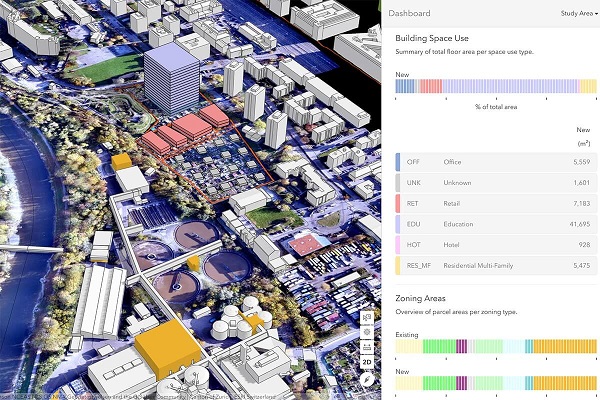
Using data from our hybrid airborne sensor, we integrate 3D Mesh models of the highest quality with semantic information. Such combination of 3D mesh models fragments with information about objects representing them is based on the results of semantic segmentation of oblique images and point clouds. Our offer includes 3D building models performed in CityGML standard at three levels of detail: LoD1, LoD2. We see the world in 3D, and hence, for certain decisions it is vital to be on the same page, beyond the orthogonal perspective. Our 3D City Models are an accurate and crisp fusion of the building geometry and texture, so that urban planners, architects and citizens alike can take better decisions. By combining high-resolution data with powerful algorithms, we produce geometrically accurate 3D models which can be used as a 3D geo-database.
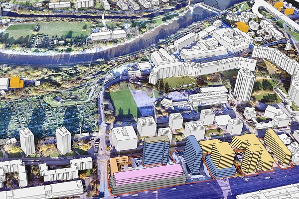
Synthetic 3D Visualization
We provide advanced 3D model of project area to perform calculations, including measuring distance, area, and volume. These are ideal for getting measurements of construction sites, calculating areas of fields, and understanding where development / installations is required and is located. Creating intricate, high quality, detailed, 3D representations and models of a wide range of objects, surfaces, landscapes, buildings, and difficult to access areas for better understanding.

Vegetation analysis
By using multispectral remote sensing data captured from our sensors, we take inventory of flora and assess vegetation in respect of species groups and plant height, simultaneously eliminating the necessity to undertake expensive field inventorying. The algorithms associated with artificial intelligence, neural networks, machine learning and deep learning are utilised for the purposes of carrying out the aforementioned analyses. We deliver geo-databases and reports tailored for the task at hand including the tree health status and an action plan ready-to-use for a sustainable management of trees.
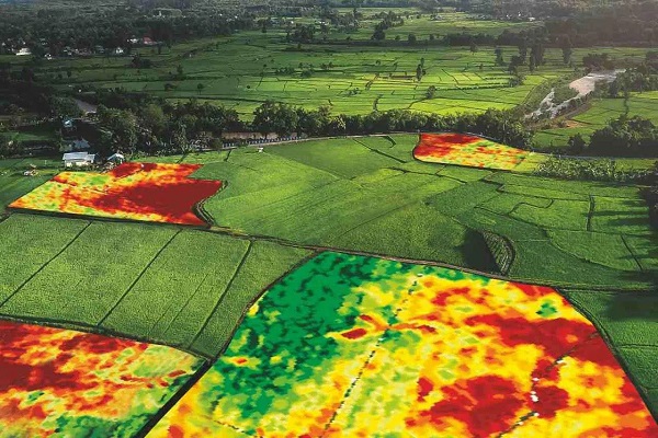
Crop Monitoring & Precision Farming
Our capability to capture multispectral data at exceptional spatial resolution—as well as determine reflectance in near-infrared—makes our solution versatile and effective to farmers & agronomists. Our mapping and analytics service for combined multispectral imaging and centimeter-level precision orthomosaic assist for farming, to produce powerful statistics on plant vigor, leaf area, canopy cover, to catch early indicators of disease, pests, and weeds and derive a true measure of the vegetative biomass of densely planted crops.
Our precision farming and crop monitoring service adds value throughout the growing season, from monitoring plant emergence right through to pre-harvest yield prediction and drainage planning for the next season. Combined orthomosaic mapping with multispectral imaging technology to gain insights on plant health. Our capability of providing a Normalized Difference Vegetation Index for powerful crop analysis and for data-driven decisions. Allocating our clients resources efficiently using infrared imaging technology to boost crop yields and performance.