Shahin Aerial Systems bring you an unrivaled, comprehensive state-of-the-art solution to the low efficiency and subpar accuracy so commonly associated with aerial LiDAR & imaging sensors. our Aerial Survey provide a very cost effective and quick means of collecting high resolution imagery and Laser Data. With a drone, it is possible to carry out topographic surveys of the same quality as the highly accurate measurements collected by traditional methods, but in a fraction of the time. We also recognise the importance of high quality professional reporting and continue to be at the forefront of innovative data gathering, post-processing methods and modern electronic reporting techniques.
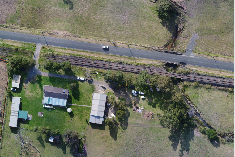
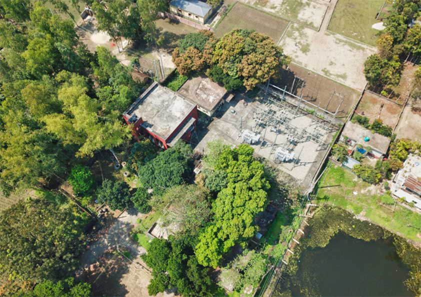
Aerial survey refers to the use of Drone or Aircraft, to capture aerial data with downward-facing sensors, such as RGB or multispectral cameras, and LiDAR payloads. During a survey with an RGB camera, the ground is photographed several times from different angles, and each image is tagged with coordinates From this data, a photogrammetry software can create geo-referenced orthomosaics, elevation models or 3D models of the project area. These maps can also be used to extract information such as highly-accurate distances or volumetric measurements of the area of interest showing aslo all natural and manmade features with levels.
Digital Aerial Photogammetry
The camera records surfaces and objects using a series of photos taken in a fly-over. By matching different photo perspectives of a single view or object, a point cloud of the object can be generated by surface matching and triangulation. Our Airborne camera system can capture ultra high resolution from 12mp to 100mp which is capable to generate upto 1cm image
Aerial Laser scanning
Our Aerial LiDAR System collect three-dimensional points simultaneously with the aerial photos, giving each individual point an RGB color value as well as a ground / no-ground classification. Airborne LiDAR units can penetrate tree foliage and can receive points where aerial camera cant penetrate. Later points to be classified as bare earth, high or low vegetation, building, and so on including RGB mode.

Mapping Large Areas
Beyond the normal scope of work sometimes happened when projects spanned hundreds of kilometers and were impossible to conduct on foot. Airplanes are also out of the question due to expenses. With our much higher resolution sensor, VTOL Fixed Wing which means we could fly higher and cover enormous area, in difficult terrain.
With our dedicated cloud processing server we can deliver a high-quality product to our client in a reasonable cost time frame.

Precision Corridor Mapping
Corridor mapping is crucial for the effective planning, design and analysis of linear infrastructure, as well as the monitoring of roads, utilities, rivers and coastlines. corridor mapping, even with a drone, is a complex task.
Shahin Geosaptial corridor features bring a new level of efficiency, as well as high accuracy and resolution, to the following types of aerial mapping projects:
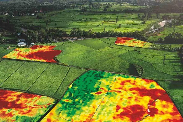
Crop Monitoring & Precision Farming
Our capability to capture multispectral data at exceptional spatial resolution—as well as determine reflectance in near-infrared—makes our solution versatile and effective to farmers & agronomists. Our mapping and analytics service for combined multispectral imaging and centimeter-level precision orthomosaic assist for farming, to produce powerful statistics on plant vigor, leaf area, canopy cover, to catch early indicators of disease, pests, and weeds and derive a true measure of the vegetative biomass of densely planted crops.
Our precision farming and crop monitoring service adds value throughout the growing season, from monitoring plant emergence right through to pre-harvest yield prediction and drainage planning for the next season. Combined orthomosaic mapping with multispectral imaging technology to gain insights on plant health. Our capability of providing a Normalized Difference Vegetation Index for powerful crop analysis and for data-driven decisions. Allocating our clients resources efficiently using infrared imaging technology to boost crop yields and performance.
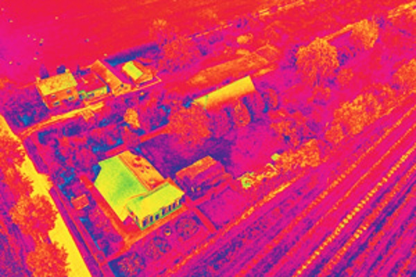
Infrared Thermography
Thermal imagery can spot excessive temperature differentials which can indicate problem areas, uncover hidden moisture damage, and identify heat leakage problems with infrared photos. Our drones can fly over installations and capture high-resolution infrared photos with high detail. Spot anomalies and identify water damage, heat leakage, or other potential problems. Thermal camera enables us to provide live, on-site thermal readouts. We are also able to provide thermal maps with a temperature value of each pixel.
Our UAV equipped with the thermal camera can be used for roof inspections, transmission/power line inspections, piping inspections, search and rescue, solar inspections and more.
Nevertheless, our infrared thermography mapping is a novel operational tool for 2D and 3D landslide surveying, mapping and characterization was explored in several instability processes (rockslides, rockfalls, earth flows-slumps) and risk management contexts.
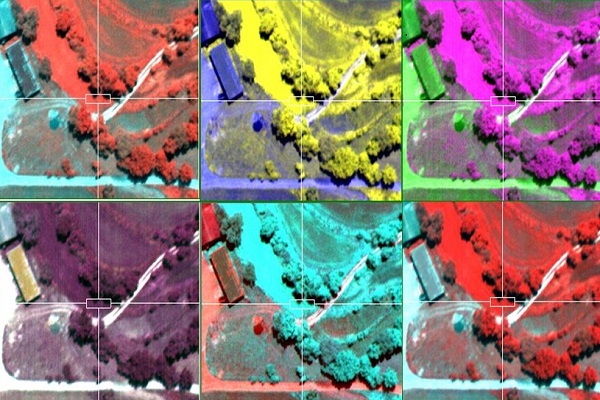
Airborne Hyperspectral Imaging
Hyperspectral imaging revealing levels of detail never before seen by the human eye. Whereas the human eye sees the color of visible light in mostly three bands (red, green, and blue), spectral imaging divides the spectrum into hundreds of bands. We are able to obtain bands of 2nm-4nm wide and even 0.3nm.
Together with our partners, our airborne hyperspectral remote sensing service extends for monitoring the development and health of crops or to detect the chemical composition of plants, e.g. to detect their nutrient and water status or pollutants or identify minerals in geology or may also use for leak detection, e.g. for gas pipelines, understand the accumulation of surface CO2 emissions, map water formations, and track the source of pollution to various regions.
Airborne Electromagnetic Survey
Aeromagnetic survey with UAV for mineral exploration & underground object detection has become ubiquitous. They can fly at a lower speed, lower altitude, and are cost-effective compared to traditional manned aeromagnetic. Both the technologies continuously upgrading.
Our first ever UAS-enabled magnetometer produce ultra-high resolution and ultra-high quality airborne magnetic survey data, quickly and safely. We measure strength of the magnetic field near to the earth’s surface and the measurements are then plotted in their relative positions and contoured in an image the patterns of measured low and high magnetic field strength in the image will reflect the position, shape and size, and magnetic properties of the rock bodies and structures within the earth’s crust. We can perform a precise aeromagnetic survey at extremely low altitudes in any terrain conditions
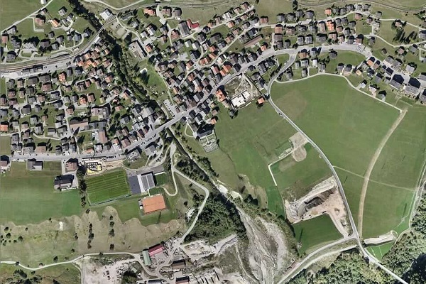
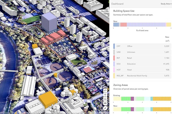
Orthomosaic Generation
Orthomosaic maps offer a photorealistic representation of an area made up from dozens of orthophotos covering all manmade and physical structure. To produce a uniform scale, images are corrected from factors including GPS, camera and environmental conditions. Images are stitched together with advanced mapping software to produce orthomosaic map.
With years of experience we generate 1cm GSD orthomosaic, accuracy down to cm can cover up several hundred sq. km.
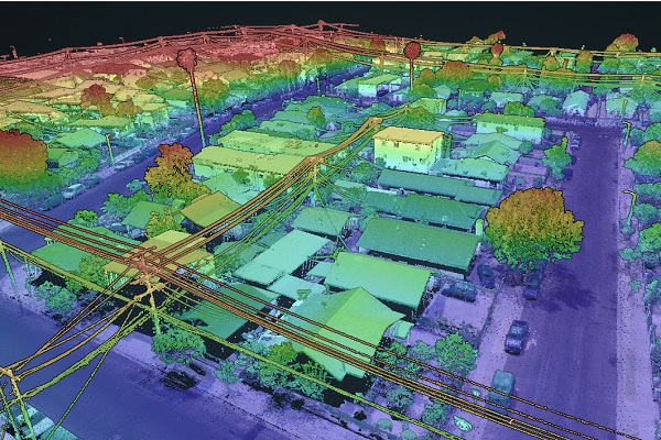
Point cloud Generation
The camera records surfaces and objects using a series of photos taken in a fly-over. By matching different photo perspectives of a single view or object, a point cloud of the object can be generated by surface matching and triangulation. For the Aerial LidarThree-dimensional point cloud is collected simultaneously with the aerial photos, giving each individual point an RGB color value as well as a ground / no-ground classification. Later points to be classified as bare earth, high or low vegetation, building, and so on including RGB mode.
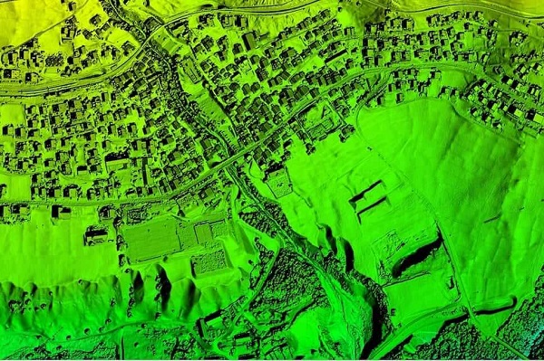
Digital Surface Modelling
Digital representation of terrain based on the height value is known as DEM. Automatic DEM can be extracted from software by using image matching algorithm.
Digital Surface Model (DSM) represents the earth’s surface and including all other objects like buildings, trees and other man made features. DSM is useful in 3D modeling for telecommunications, urban planning and aviation. Infrastructure damage assessment is anlysed by DSM
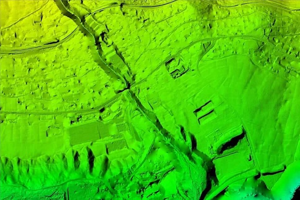
Digital Terrain Model
Digital Terrain Model (DTM) represents the bare earth ground model only, no other features like buildings, trees and other man made features will be available in this file.Our processed Model can used to analyse through Base mapping, Contour creation, Water flow modeling. Rectification of aerial photography, Line of sight analysis, Surface analysis, 3D visualization rendering Engineering and Infrastructure design..
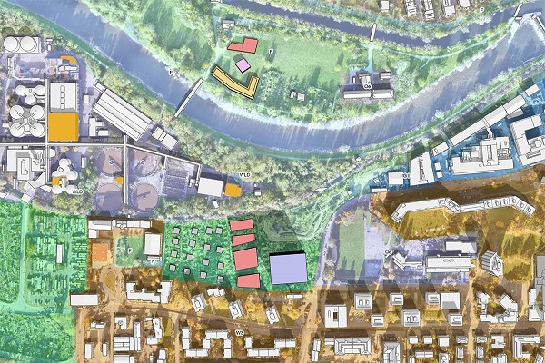
Photogammetric Feature Extraction
Aerial Systems generate high-resolution orthomosaics and detailed 3D models of areas where low-quality, outdated or even no data, are available, enabling high accuracy cadastral maps to be produced quickly and easily, even in complex or difficult to access environments. We extract manmade features from the images, such as buildings, roads, drains, bridges and physical features, topography, rivers, lakes and so on at different scale and different formats on the customer requirement and the image resolution.
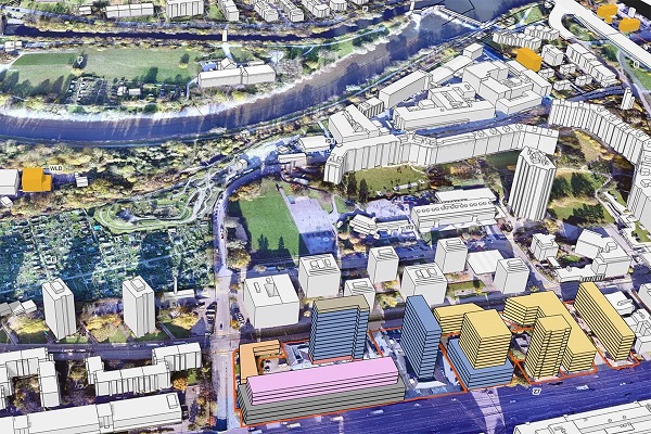
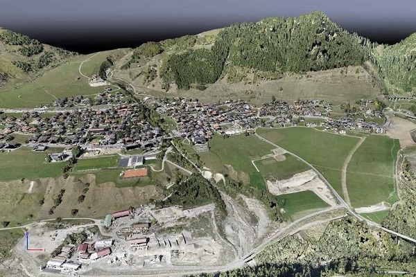
Synthetic 3D Visualization
We provide advanced 3D model of project area to perform calculations, including measuring distance, area, and volume. These are ideal for getting measurements of construction sites, calculating areas of fields, and understanding where development / installations is required and is located. Creating intricate, high quality, detailed, 3D representations and models of a wide range of objects, surfaces, landscapes, buildings, and difficult to access areas for better understanding.
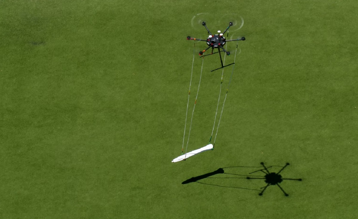
Measurement: Distance, Area & Volume
Aerial system can fly almost anywhere. No longer limited by unreachable areas or harsh terrain or unsuitable events for traditional measuring tools. Each pixel of the produced map or point of the 3D model contains 3D geo-data. Interact with the model and use it to perform calculations, including measuring distance, area, and volume. These tools are ideal for getting measurements of construction sites, calculating areas of fields, and understanding every critical details visualized in Orthophoto and DEM. Through 3D data, we also measure volume. This fast and inexpensive method of volume measurement is particularly useful to calculate stocks in mines and quarries for inventory or monitoring purposes. Since drones are capturing the data from above, operations on site won’t be interrupted. The short acquisition time enables capturing a site snapshot at a specific point in time.
Drone inspection services
Through our Drone based inspection service, it possible to access areas that may pose health, safety and environmental risks in a fast and safe way. We can navigate very close structures, allowing them to capture minute details. We take high-resolution images or video that clearly show cracks, damage, misplaced wires and other defects at elevations and angles that humans cannot access or maneuver. This allows for collection of more comprehensive data without exposing the inspection team to risks. We also provide 3d visualization assist in the improvement of safety and quality while minimizing any negative environmental impact.Our multispectral imaging can find the parameter of environmentally degradable components.