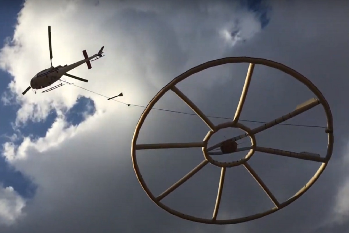
Aerial data acquisition, is the first step in geospatial analysis projects. It will define the road you want to follow. Our own fleet of aircrafts, helicopters and high technology sensors make us able to capture your data anywhere in the world.
We based on the combination of laser scanner, a high-resolution digital aerial camera, very high quality direct georeferencing navigation system (gps-imu) & airborne spectrometer. We have both fixed wing & helicopters.
Our offer includes a wide range of services from the air: the recording of aerial photographs, oblique images, thermal images, laser data, spectral images & airborne electromagnetic spectrometer. From this basic data, we generate numerous products such as digital orthophotos, true orthophotos, surface and terrain models, image-based surface models (bdom), 3d city models, 3d meshes, powerline mapping data and input data for building information modeling (BIM).
Your data acquisition partner all over the world
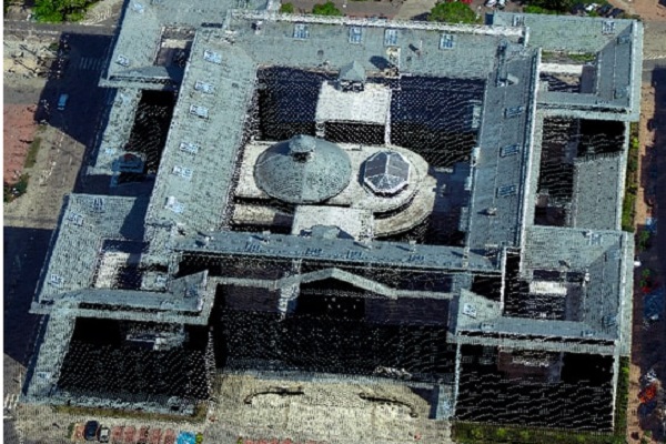
Laser scanning
The advantage of airborne laser scanning is that you can get very good documentation of the terrain even in areas with a lot of vegetation. This allows the method to calculate a terrain surface with substantially greater accuracy and reliability than with other techniques. The point cloud is further processed by separating different objects such as terrain surface, vegetation, buildings, power lines etc.
We operate different LiDAR sensors installed in the aircraft, they register millions of ground points with frequencies up to 400kHz and 1000kHz ! They are fitted with an Inertial Measurement Unit (IMU) and a flight management system . Accuracy can reach +/- 2 to 20cm. The main advantage is quick acquisition: it's possible to acquire 1,000 square kilometers within 2 days of flight.
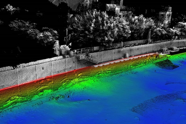
Bathymetry Laser Scanning
We gathers laser data both on land and in water, using airborne laser scanning; well suited for surveying shallow waters and land areas with high accuracy and precision. When collecting depth data in shallow coastal sea areas along the beach zone, the data will contribute to a comprehensive terrain model that binds traditional topographic data together with sonar data collected from boat-based systems. The data collected is compiled and usually delivered to a customer as a terrain model or elevation contours, possibly also with orthophoto as an additional product. Such a solution appears to be perfect in the context of executing projects consisting in scanning of wetlands and floodlands, monitoring of coastlines, as well as analysing watercourses and waterways.
Oblique Imagery
Diagonal photos taken at an angle of about 45 degrees are becoming more and more popular. During the raid, the image from 4 cameras directed in four directions N, S, W, E is simultaneously recorded. We provide both raw oblique photos, photos with georeference, and oblique orthophotos . Diagonal photos can be used, for example, to develop interesting visualizations showing monuments, revitalized areas, attractive locations and interesting investment areas.
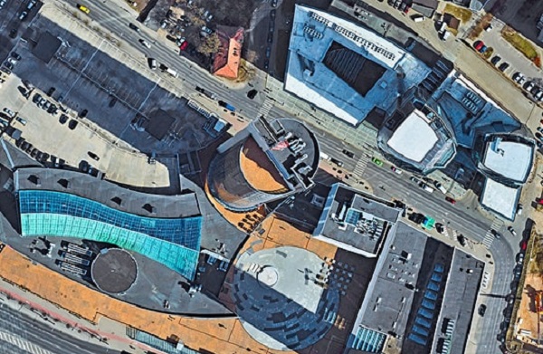
Vertical Imagery
We make vertical aerial photos with spatial resolution from 1 cm (GSD). The type of camera, spatial and spectral resolution (R, G, B, NIR) and photo processing technology are adjusted to the customer's needs. The delivered product can be raw photos or photos with georeferencing (orthoimages). Vertical aerial photos allow for all kinds of photointerpretation.
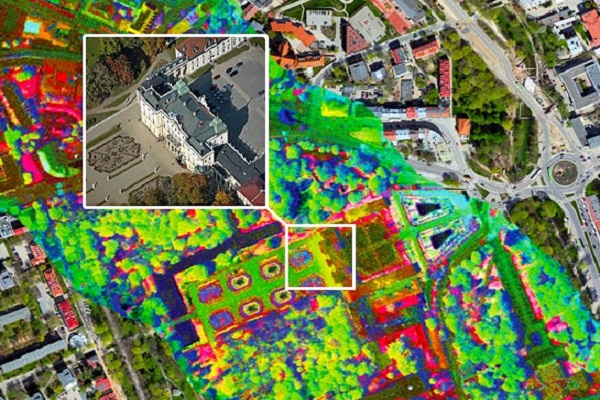
Hyperspectral Vertical Imagery
Our hyperspectral orthophoto covers the visible light spectral regions (400-700 nm), near infrared (700-1000 nm) and short-wave infrared (1000-2500 nm) in nearly 500 channels. With such accuracy one can uncover even small differences in the spectral signature in the surface, which can then be used for different classification. The possible applications are almost endless. Urban planners, environmental researchers, forest owners, road managers and most people can access unique decision-making and planning tools.
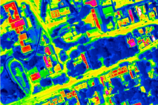
Thermal imaging
By using aerial thermal cameras, it is possible to obtain images allowing for determination of ground temperatures and structure temperatures over large areas, e.g. in urban areas. Processing of such images into thermal maps enables us to indicate the locations of heat losses, moisture accumulation or sewage discharge. The equipment which we possess is capable of recording thermal radiation and temperature differences at the level of 0.005 °C.
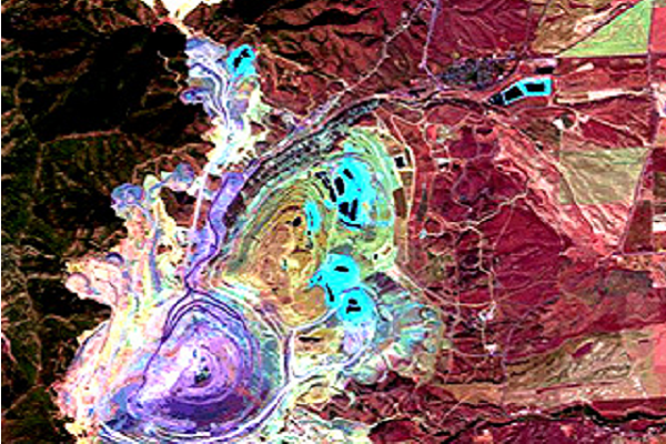
Airborne Geophysics
Airborne geophysical imagery provides a continuous view of the surface and subsurface geology down to a depth of several hundred metres. Depending on the sensors carried by an aircraft or helicopter, several characteristics of the subsurface can be investigated rapidly despite forest cover or difficult terrain. This tool is a valuable decision-making aid when prospecting for raw materials, from regional targeting to the characterisation of deposits. Airborne geophysical sensing cross-referenced with the study of available drilling data, and supplemented by targeted geological field checks, provides 3D imaging of the information being exploited and/or of interest, quickly and at a lower cost. Alterations in mineralogy, moisture content, stratigraphy, porosity and salinity have the potential to be detected by airborne electromagnetic (EM) surveys and can be represented in three dimensional images. Airborne magnetic surveys map variations due primarily to the magnetite content of rock. Radiometric surveys measure the radiation of one or more of the earth’s natural radioelements – potassium, uranium, and thorium.
Multisensor data
multi-sensor aviation platform, we offer simultaneous acquisition of several sets of remote sensing data. The platform integrates the operation of several sensors placed on board one aircraft. This makes it possible to obtain a complementary and coherent set of data during one aviation mission. The composition of the set of sensors is tailored to the individual needs of the client from RGB, NIR, thermal, ALS and hyperspectral scanners. The simultaneous acquisition of data from many sensors enables, among others conducting comprehensive inventories of urbanized space and the natural environment, as well as advanced remote sensing analyzes.
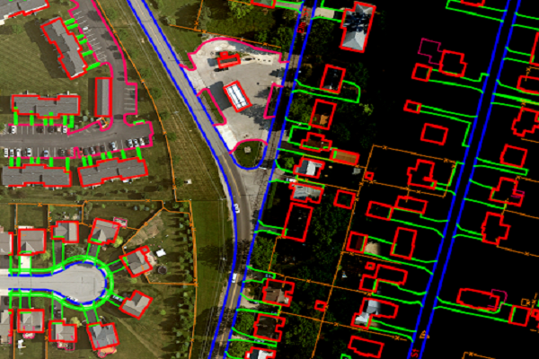
Vectorisation
We develop two-dimensional vectorization, as well as three-dimensional feature extraction based on Orthophoto and classified cloud of LiDAR points. The end-product of this process is an editable delaminated vector file featuring division into surface structures, linear structures, point structures, text descriptions and editorial components. 3D/2D vectors can then be overlayed on to Ortho / True Ortho imagery to generate highly presentable and thematic maps. City-wide as well as country-wide maps are created with absolute accuracy leveraging results from extreme image processing, geo-referencing and applying specialized process.
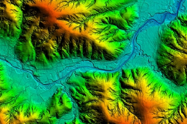
Terrain models
Based on the point cloud obtained during airborne laser scanning, we develop terrain models. The Digital Terrain Model (DTM) is a faithful representation of the terrain relief. The Digital Surface Model (DSM) is a model of the terrain supplemented with objects located on the ground surface. The use of DTM and DSM is wide and may include: making profiles, determining land slopes and angles, determining the height of terrains and objects, identification of relief forms, inventory of objects.
Orthophotomap
The orthophotomap is created as a result of processing aerial photos. Contrary to the aerial photo, it is characterized by an orthogonal projection and a uniform scale for the entire terrain surface. It has cartometric features appropriate to the map. It can be developed in the composition of real (R, G, B) or unreal colors using the near infrared (NIR, R, G). In addition to carrying out various types of photointerpretation, the orthophotomap also enables measurements of recorded objects.
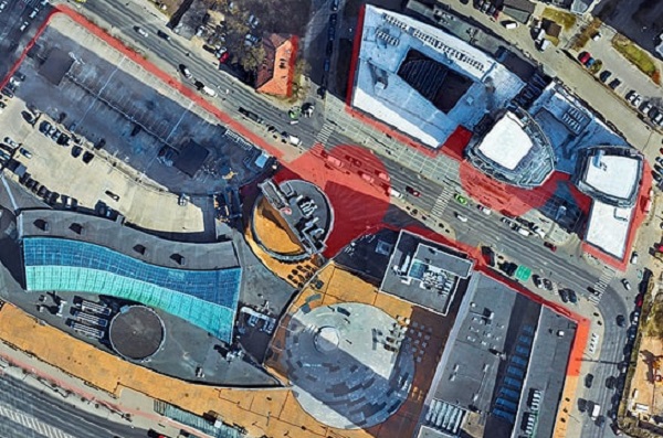
True orthophotomap
A true ortho map has the additional advantage of lacking the so-called lying objects. Not only objects on the site, but also tall buildings such as buildings, are rectified to an orthogonal position eliminating blind spots (areas obscured by tall buildings). True orthophotomap allows you to carry out various types of photointerpretation and perform detailed measurements of objects, including tall objects.

Semantic 3D Mesh models
Using data from our hybrid airborne sensor, we integrate 3D Mesh models of the highest quality with semantic information. Such combination of 3D mesh models fragments with information about objects representing them is based on the results of semantic segmentation of oblique images and point clouds. Our offer includes 3D building models performed in CityGML standard at three levels of detail: LoD1, LoD2. We see the world in 3D, and hence, for certain decisions it is vital to be on the same page, beyond the orthogonal perspective. Our 3D City Models are an accurate and crisp fusion of the building geometry and texture, so that urban planners, architects and citizens alike can take better decisions. By combining high-resolution data with powerful algorithms, we produce geometrically accurate 3D models which can be used as a 3D geo-database.

Vegetation analysis
By using multispectral remote sensing data captured from our sensors, we take inventory of flora and assess vegetation in respect of species groups and plant height, simultaneously eliminating the necessity to undertake expensive field inventorying. The algorithms associated with artificial intelligence, neural networks, machine learning and deep learning are utilised for the purposes of carrying out the aforementioned analyses. We deliver geo-databases and reports tailored for the task at hand including the tree health status and an action plan ready-to-use for a sustainable management of trees.