Hydrographic surveying is an extremely specialized function. Our professional experience, acquiring sonar data in the most challenging coastal environments. The hydrographic surveys performed by Shahin Geospatial adhere to IHO Hydrographic Survey Standards. We use state-of-the-art positioning and multi-beam sounding equipment. Our survey vessels are capable to access shallow areas and can collect data right up to the structure. Using RTK-GPS for precise positioning, multi-beam echo-sounders for depth measurement, and ancillary sensors can collect very accurate data sets that can be used to develop detailed models of the under water bottom.
These models can be used to calculate volumetric quantities of scours holes, voids, and sediment build-up to a high degree of accuracy.. Deliverables will include full color digital images, georeferenced data sets, and 3-dimensional models that give the viewer a lifelike view of bottom conditions. Using bathymetric data, we can get a precise description of sea beds, river floors and sanitation facilities (transport, capture, etc.). We can accurately measure the sedimentation rate and monitor its fluctuations. It’s a great additional tool for topographic surveying.
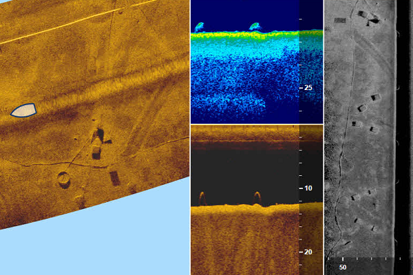
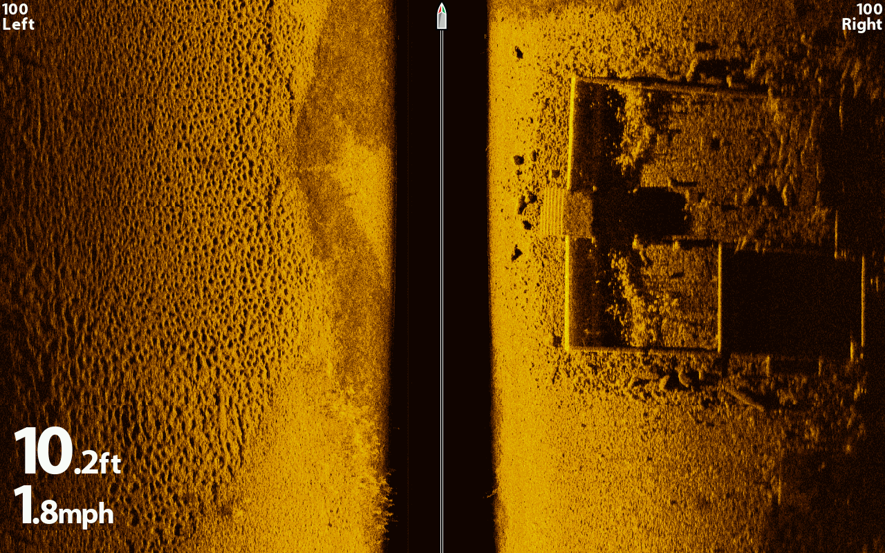
SIDE IMAGING
It's all in the details. We usually record 180 degrees side-to-side perspective on the world below the surface with remarkable incredible view to both sides of vessel. Delivering up to 3X the output of standard Side Imaging, our Side Imaging sensors works megahertz. And there’s absolutely no place left to hide, In an instant, the ultra-thin beam scans the area up to 400 feet to the left and right of vessels - for total coverage of up to 800 feet. The return image for each slice is then added to the images taken immediately before and after to build an incredible view of the bottom. We can mark GPS location of bottom or structure directly on the screen. We can generate geo-referenced raster images from sidescan sonar recordings.
Depth Logging
Our system Track-log data is collected on a GPS/Sonar unit. Units save depth information as part of the breadcrumb trail that is continuously produced when the unit is in use. This means that the unit is always generating usable track-log data. This consists of GPS, Depth & Time. The digital depth is output from unit over the NMEA interface once every second. This can be directed to a personal computer or laptop computer for real time depth recording. Sonar log files contain latitude, longitude, depth and time information for each track point, as well as the raw sonar data from each sonar ping and, often, further information such as water temperature, speed and course. As sonar log files contain so much more information than GPS track files, they are often used to create maps.
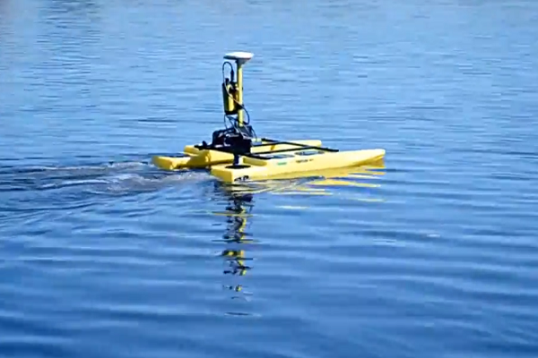
USV Data logging
Our Unmanned Surface Vessel conssits of modern autopilot, GPS, SONAR & Cameras where manned boating is challenging & dangerous. USV to create underwater high-resolution orthophoto mosaics and digital surface models. The images can be used to create 3-dimensional models that provide very detailed images and measurements that can be used to monitor changes.
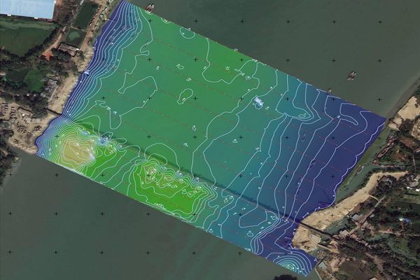
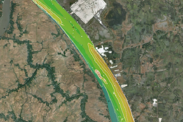
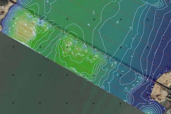
Shallow Water Mapping
Surveying with the use of specialized hydrographic sensors such as Sidescan Sonar, we are able to provide detailed information of River Bed and seafloor characteristics. After generating High Resolution Digital Teraain Model and 3D Perpectives Bathymetry imagery shows a clear difference between shapes showing what appears to be “normal” erosion and violent, sudden landslides
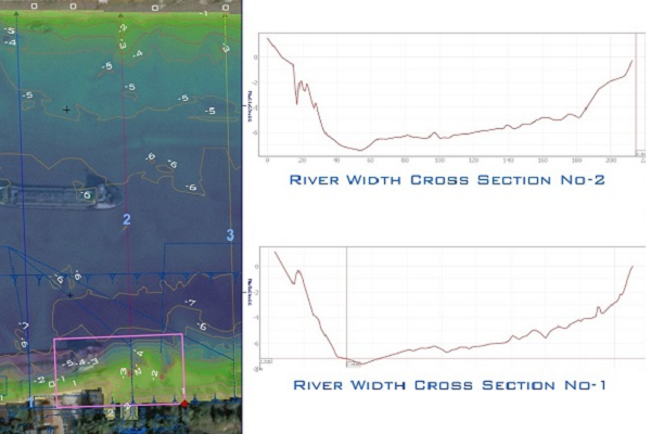
Channel / River cross Section
With the help of echo-sounding or sonar data we are capable to find river depth in various locations from the river. The height is geographically coordinated and after processing through GIS software we can deliberately provide cross section either by interval or continuous.
Coastal / Tidal River Mapping
Shahin Geospatial provides coastal survey services for a variety of industry needs. From coastal inlets to river mouths, hydrographic survey is a necessity for understanding sediment transport systems. We provide the highly accurate data necessary for coastal management projects.
Underwater Search and object detections
Shahin Geospatial provides hydrographic search and location services. From positioning & locating sunken debris, Shahin Geospatial has the capability to locate most any objects within coastal waters. Using efficient search patterns and high resolution sensors, Shahin Geospatial has the experience and equipment to complete target detection projects.
Our systems sweeps up to 200 feet in every direction around vessel deliver the clearest images ever seen of structure. There’s absolutely no place left to hide, Our down Imaging technology shows what lies beneath in crystal-clear detail. Our incredible snapshots provides Crystal clear under water image includes GPS position and depth, which is absolutely best for underwater search operation.
Sediment Calculation
We offer sedimentation surveys in addition to volumetric surveys. The sedimentation survey is built upon the volumetric survey. The volumetric survey will tell us what the current capacity is while the sedimentation surveys show us what the capacity used to be before or after.
We can use these to project out a rate of sedimentation over time because we know what it started with and at now. Once we have that rate, we can project into the future and determine what the reservoir capacity might be in 10 or 20 years. Our service includes more realistic data/estimate regarding the rate of siltation and criteria for studying the status over a definite period of time with particular reference to reduction of intended benefits in the form of irrigation potential, hydropower, flood absorption capacity
Scour Monitoring
Naturally, sediment is transported and shaped by the movement of water through the environment. Bridges and piers that are constructed in waterways rely on stable sediment for structural integrity, which can be compromised by scouring. Scour monitoring systems can alert the appropriate people when levels of scour reach a point that structural damage can occur.